IFR weather raw data, CRAFT clearances, IFR planning — and the Halim Perdanakusuma (WIHH) SID, STAR, approach and aerodrome charts.
GT
Bagus HandryantoFlight Instructor
Read the chart before it reads you.
Opening
Competency standard
The learner can decode IFR weather raw data, plan an IFR flight, copy and read back long clearances and fly the published SID, STAR and approach procedures at Halim Perdanakusuma (WIHH).
01
Decode
Real METAR, TAF and SIGMET messages for WIHH — and turn them into a go / hold / divert decision.
02
Plan
An IFR flight plan that works: preflight information, route & MEA, fuel, SID climb gradient and the alternate decision.
03
Communicate
Copy a long IFR clearance with CRAFT, read back correctly, and handle lost communications in IMC.
04
Fly the chart
Read every element of the WIHH SID, STAR, approach and aerodrome charts — constraints, holds, frequencies, minima.
Each section ends with a 5-question quiz. The next section unlocks only after the quiz is complete.
Opening
Course map
WeatherPlanClearanceDepart · ArriveLand
Sources: FAA-H-8083-15B (IFH) · FAA-H-8083-16B (IPH) · AIM ch. 4, 5, 6, 7 · AC 00-45H · 14 CFR 91.167/169/185 · AIP Indonesia WIHH AD 2.24 · aviationweather.gov
A
Every letter in a METAR is a decision waiting to happen.
Section A
IFR weather raw data
We read real reports from Halim — the way they arrive on your phone or the briefing office printer: raw, coded and unforgiving.
Format: ICAO Annex 3 / WMO FM 15 (metres, hPa) — FAA AC 00-45H explains the U.S. variant (statute miles, inHg). Flight categories per FAA: VFR · MVFR · IFR · LIFR.
A3 · TAF — terminal aerodrome forecast
Read the TAF at your ETA
FM / base
TEMPO
BECMG
In force at ETA
Group
Tap a group in the TAF above.
Real TAF WIHH 070500Z · aviationweather.gov · BECMG = gradual permanent change during the period · TEMPO = fluctuations each < 1 h, in total < half the period
A4 · SIGMET — significant meteorological information
Plot the SIGMET
Group
Illustrative training SIGMETs in ICAO Annex 3 format — not issued messages. WIIF = Jakarta FIR, WIII = issuing MWO. Simplified coastline.
A5 · Altimetry
Transition & QNH errors
Climb out of WIHH — when do you change the setting?
Wrong QNH — where is the aircraft really?
≈ 27–30 ft per hPa near sea level (1 inHg ≈ 1,000 ft — FAA-H-8083-25 ch. 8). Cold-temperature error ≈ 4% per 10 °C below ISA — rare at Halim, critical at high, cold aerodromes (AIM 7-3).
A6 · Cases
What would you do?
Quiz · section A
Section A quiz
Loading questions…
Answer all 5 to unlock section B.
B
Most IFR emergencies start on the ground, in the planning.
Section B
IFR flight planning
Information, route, fuel, performance and an escape plan — before engine start.
B1Preflight setinformation & route
B2Fuelcomponents
B3Climb gradientft/NM → fpm
B4Alternate1-2-3 rule
B1 · Preflight action
The IFR preflight set
Preflight complete0 / 8
B2 · Fuel planning
Build the fuel figure
Minimum block fuel (US gal)
14 CFR 91.167 (IFR): destination + alternate + 45 min at normal cruise. ICAO Annex 6 style: taxi + trip + contingency (5%) + alternate + final reserve (30 min) + extra. Use your operator’s OM where it applies.
TERPS (FAA Order 8260.3): obstacle clearance surface 40:1 = 152 ft/NM; standard minimum climb 200 ft/NM (3.3%) unless a higher gradient is published. Climb gradient tables: FAA TPP legend.
B4 · Alternate requirement
Do I need an alternate?
WIHH TAF 070500Z — window ETA ± 1 h
14 CFR 91.169
1hour before to 1 hour after ETA
22,000 ft ceiling or higher
33 SM (≈ 4,800 m) visibility or more
Otherwise file an alternate. Standard alternate minima when no special minima are published: precision approach 600 ft & 2 SM, non-precision 800 ft & 2 SM.
TEMPO groups are treated as applicable — conservative practice. Indonesian operators: follow CASR Part 91/121/135 and your OM; the FAA rule is shown as the reference standard.
Quiz · section B
Section B quiz
Loading questions…
Answer all 5 to unlock section C.
C
Your memory holds 7 items for 20 seconds. A clearance has more.
Section C
IFR communications
Long clearances, busy frequencies and similar call signs. The tools: CRAFT, disciplined readbacks, and a plan for when the radio goes silent.
C1CRAFTcopy any clearance
C2Readback& hearback
C3Lost comms7600 · AVE-F
C1 · CRAFT
Copy it with CRAFT
HALIM GROUND 118.6
CClearance limit
RRoute
AAltitude
FFrequency
TTransponder
Training example in ICAO / FAA phraseology (AIM 4-4-3, 4-4-7). Frequencies from the WIHH ADC and SID charts. Call sign PK-VDE is fictitious.
C2 · Readback & hearback
Close the loop
Always read back — tap each to see why
Phraseology: “Say again” · “Confirm …” · “Unable” · “Wilco” — never “Roger” for a level or heading.
C3 · Lost communications
When the radio goes silent
14 CFR 91.185 · AIM 6-4 · ICAO Doc 4444 §15.3 — in Indonesia, apply the radio-failure procedures published in AIP Indonesia where they differ.
Quiz · section C
Section C quiz
Loading questions…
Answer all 5 to unlock the WIHH charts.
D
A line under a number and a line over it — two very different clearances.
Section D
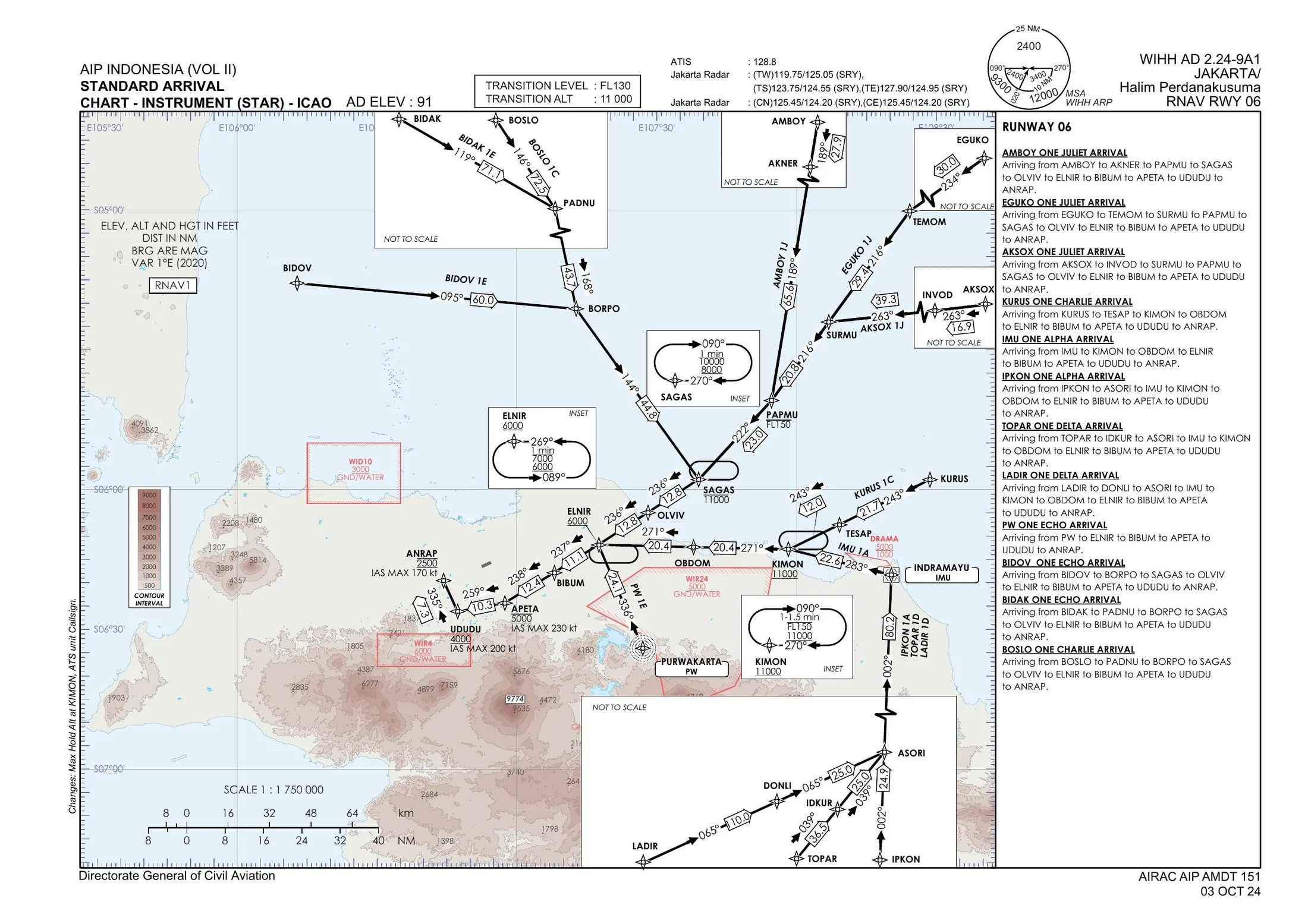
WIHH SID & STAR
The real Halim Perdanakusuma RNAV charts from AIP Indonesia — read, decoded and flown leg by leg.
D1Anatomyevery box on the chart
D2SID RWY 06ABASA 1E · PW 1G
D3Codingconstraints · legs
D4SID RWY 24the inset
D5STARAMBOY 1J · holds
D6Via & runway change1J → 1K
D1 · WIHH AD 2.24-7A1 · SID RNAV RWY 06
Chart anatomy
D2 · SID RNAV RWY 06
Fly the SID
D3 · Reading the coding table
Lines, signs & legs
Altitude constraints — as printed on the WIHH charts
2500
At or aboveUnderline · coding +2500 · EPDIP on ABASA 1E
FL150
At or belowOverline · coding -FL150 · BORPO on ABASA 1E
4000
At — mandatoryBoth lines · coding @4000 · UGPOX on PW 1G
800010000
WindowBetween two values · SAGAS hold 8,000–10,000
Entries: AIM 5-3-8 / ICAO Doc 8168 (direct 180°, teardrop 70°, parallel 110° sectors). Max holding speed ICAO: 230 kt up to FL140 · FAA: 200 KIAS to 6,000 ft, 230 KIAS 6,001–14,000 ft.
D6 · Via clearances & a runway change
“Via”, “except” & RWY 06 → 24
ATC
Quiz · section D
Section D quiz
Loading questions…
Answer all 5 to unlock section E.
E
The last 10 miles decide whether you land. Brief them properly.
Section E
Approach & aerodrome
From the end of the STAR to the parking stand: the aerodrome chart, the anatomy of an approach chart, and the 3° glide path.
E1Aerodrome chartWIHH AD 2.24-1
E2IAP anatomyILS RWY 24 layout
E3Glide path& approach briefing
E1 · WIHH AD 2.24-1 · Aerodrome chart
Halim on one page
E2 · Instrument approach procedure chart
Approach chart anatomy
Teaching layout — not for navigation. Real WIHH data from the ADC (LOC IHAL 111.7, GP 333.5, RWY 245°, THR 91 ft, HLM 113.3). Altitudes and minima shown as “AIP” must be read from the current WIHH AD 2.24 IAP chart. Order: FAA-H-8083-16B ch. 4.
E3 · Glide path & briefing
Fly the 3° slope
Height above THR
Rate of descent
Altitude (THR 91 ft)
Approach briefing — top to bottom
Height ≈ 318 ft/NM (tan 3° × 6,076). ROD = GS × 101.3 × tan 3° ≈ GS × 5.3. Stabilized approach: FAA AC 120-71B — stable by 1,000 ft in IMC.
Quiz · section E
Section E quiz
Loading questions…
Last quiz — answer all 5 to unlock the review.
Closing · review
How was the lesson?
Your rating helps the instructor improve. Give 1–5 stars for each aspect.
Loading…
Closing
Brief it. Fly it.
A
Decode the METAR, TAF at ETA and SIGMET. TA 11,000 / TL FL130 — 10 hPa wrong ≈ 300 ft.
B
fpm ≈ % × GS. Fuel to destination + alternate + reserve. 1-2-3 decides the alternate.
C
Copy with CRAFT, read back levels in full, and if silent: 7600 · AVE-F · highest altitude.
D
Under = above, over = below, both = at. “Via” keeps the restrictions; “except” changes one.
E
ILS IHAL 111.7 serves RWY 24. 3° ≈ 300 ft/NM, ROD ≈ GS × 5. Brief top to bottom.

 Answer all 5 to unlock section B.